
 isnaini azizah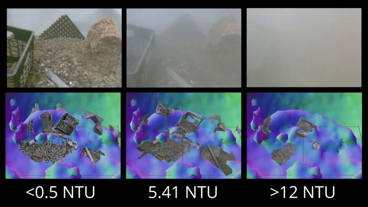
When remotely operated vehicles (ROVs) descend to the seafloor or disturb a sand bed during their scientific missions, they inevitably churn up clouds of sediment. These suspended particles create an opaque veil, rendering onboard cameras virtually useless and forcing operators to halt operations and patiently wait for the murky waters to clear – a process that can be frustratingly slow and inefficient, particularly in dynamic underwater environments. This common obstacle, a persistent challenge in marine robotics and exploration, has long hampered the ability of these sophisticated machines to perform their tasks with precision and speed. However, a groundbreaking new system developed by Amy Phung, a graduate student at the Woods Hole Oceanographic Institution (WHOI) pursuing her Master of Science (SM) in 2023 and her Doctor of Philosophy (PhD) in 2026, in collaboration with her advisor Richard Camilli, a distinguished WHOI alumnus who earned his SM in 2000 and PhD in 2003, promises to revolutionize underwater navigation and observation, offering a robust solution to the persistent problem of sediment-induced visibility loss.
The innovative technique hinges on a sophisticated, dual-pronged approach that leverages the strengths of both sonar and advanced image-processing algorithms. Initially, the ROV employs its onboard sonar system to rapidly generate a detailed map of its immediate surroundings. While sonar technology does not offer the high-resolution visual fidelity of cameras, its critical advantage lies in its unwavering effectiveness regardless of water clarity. Sonar waves can penetrate even the densest sediment plumes, providing a reliable acoustic picture of the environment. This initial sonar mapping allows the ROV to navigate safely and efficiently, even when visibility is near zero, guiding it to a position where it can bring its cameras to bear on specific objects of interest with a much higher degree of accuracy and confidence. The ability to get close to targets without relying solely on visual cues is a significant leap forward, minimizing the risk of accidental collisions or damage to delicate marine ecosystems.
To overcome the processing demands of real-time sonar mapping and ensure that the system can operate dynamically, Phung and Camilli integrated the sonar technology with a sophisticated image-matching algorithm. This algorithm, originally developed by a team of researchers in France, is adept at quickly estimating the relative depth of each pixel within a two-dimensional scene. By combining the spatial information from the sonar with the pixel-level depth estimations from the algorithm, the system can construct a comprehensive and navigable 3D representation of the environment, even in conditions where visual data is compromised. This synergy between acoustic sensing and advanced computational analysis allows the ROV to "see" through the sediment clouds, enabling it to perceive its surroundings in a way that was previously impossible.
Richard Camilli eloquently illustrates the transformative nature of their new technique with a vivid analogy: "An analogy would be if you were to go into a china shop in the dark, and try to pick your way around to find a specific coffee mug without knocking things over." This relatable scenario highlights the inherent difficulty of navigating complex environments with limited sensory input. The new system, in essence, provides the ROV with an "invisible touch," allowing it to build a mental map of the china shop, identify the coffee mug’s location, and maneuver towards it with confidence, all while avoiding the delicate porcelain. This capability is not merely an incremental improvement; it represents a fundamental shift in how underwater vehicles can operate in challenging conditions.
The potential applications of this groundbreaking technology are vast and far-reaching, promising to enhance a wide array of underwater operations. In the realm of scientific exploration, researchers will be able to conduct detailed surveys of the seafloor, collect samples, and deploy instruments in areas previously deemed too challenging due to sediment disturbance. This could unlock new insights into deep-sea ecosystems, geological formations, and the distribution of marine life. For instance, studying hydrothermal vents, which often release plumes of particulate matter, or investigating shipwrecks covered in silt, will become significantly more feasible and less time-consuming.
Beyond pure scientific endeavors, the system holds immense promise for underwater construction and maintenance. The installation and repair of subsea infrastructure, such as pipelines, cables, and offshore wind turbines, frequently involves working in sediment-rich environments. The ability of ROVs to accurately position themselves, identify components, and perform delicate tasks in these conditions will lead to greater efficiency, reduced risk of operational delays, and potentially lower costs for these critical projects. Imagine a technician needing to inspect a pipeline junction on the seabed that has been disturbed by currents; this new system would allow the ROV to confidently navigate to the exact spot and provide clear, actionable information.
Perhaps one of the most critical and life-saving applications lies in the handling and disposal of unexploded undersea mines. These dangerous remnants of past conflicts pose a significant threat to maritime traffic and coastal communities worldwide. Locating, identifying, and safely neutralizing these mines often requires highly specialized ROVs operating in challenging environments. The ability of Phung and Camilli’s system to navigate through sediment clouds with precision and reliability could significantly improve the safety and effectiveness of mine countermeasures operations, reducing the risk to human divers and naval personnel. The precision offered by this technology is paramount when dealing with such volatile ordnance, where even minor miscalculations can have catastrophic consequences.
The development of this system represents a significant advancement in marine robotics, addressing a long-standing limitation that has constrained underwater operations. The integration of sonar’s broad-area sensing with the fine-grained depth estimation of advanced algorithms creates a powerful synergy that allows ROVs to overcome the veil of sediment. The real-time processing, facilitated by the French image-matching algorithm, ensures that this capability is not a theoretical concept but a practical tool that can be deployed in dynamic, operational settings.
The implications for future underwater research and industry are profound. As exploration pushes into ever more challenging and dynamic environments, the need for robust and reliable navigation and sensing technologies will only increase. This new system, born from the ingenuity of Phung and the expertise of Camilli at WHOI, stands as a testament to the power of interdisciplinary collaboration and the relentless pursuit of solutions to complex scientific and engineering problems. It promises to open up new frontiers in our understanding and utilization of the ocean, making its hidden depths more accessible and its challenges more surmountable. The ability to "see" through the murk is no longer a distant dream but a tangible reality, poised to redefine the capabilities of underwater exploration and intervention for years to come. The researchers’ meticulous work has not only addressed a fundamental limitation but has also paved the way for safer, more efficient, and more ambitious endeavors beneath the waves.